During the 19th century there were large amounts of unused arable federal land in the USA, land that wasn’t cultivated. To speed up the colonization westward the US Federal Government gave land to settlers willing to cultivate and live on an allotted piece of land (so-called homesteads). This was regulated in several United States federal laws called Homestead Acts.The land acreage cultivated by settlers constantly expanded westwards. The expansion westward was slow in the beginning but sped up after the Homestead Act of 1862 when homestead land was granted for free. During the large peak of immigration from Sweden, 1865 – 1873, there were still free homestead lands available in the Upper Mid-West. States such as Illinois, Wisconsin, Iowa and above all Minnesota became areas where the Swedish immigrants to the USA settled.
Homestead Acts
The Homestead Acts were several United States federal laws that gave an applicant ownership of land, typically called a "homestead", at low or no cost. The distribution of Government lands had been an established practice since the Revolutionary War. One of the early homestead ordinances dates back to 1841 (The Preemption Act of 1841). This ordinance consisted of grants totaling 160 acres (65 hectares, or one-quarter section) of unappropriated federal land within the boundaries of the public land states. This land was sold to applicants for 1.25 dollars per acre (1 acre is about 4,000 m2).The most well-known act is the Homestead Act of 1862. This act was signed into law by President Abraham Lincoln on May 20, 1862. Anyone who had never taken up arms against the United States government, was 21 years or older, or the head of a family, could file an application to claim a free federal land grant. There was also a residency requirement and a small registration fee.The occupant of homestead land had to reside on the land for five years, and show evidence of having made improvements like clearing the land and cultivating the ground. There was no need to be a citizen, immigrants also could claim land. Under the Homestead Act, the head of a family could lay claim to up to 160 acres [65 hectares = 0.65 km2, for example an area of about 800 x 810 m (875 x 886 yd.)] of surveyed Government land.The homestead acquisition was a three-fold process:1. Filing an application to claim a free federal land grant2. Living on and improving the land3. Filing for deed of title (land patent) for the land after 5 yearsSo, after 5 years, the homesteader could file for his patent by submitting proof of residency and the required improvements to a local land office.Six months after the Homestead Act was passed, the Railroad Act was signed, and by May 1869, a transcontinental railroad stretched across the frontier.The large railroad companies sold excess land to the settlers. When the railroads progressed westward the railroad companies were granted land by the Government, more land than needed for the tracks. It could be up to 15 - 20 km (15 miles) on both sides of the tracks; therefore they sold excess land to settlers and thereby were able to further finance their projects. The railroad companies were interested in getting communities to grow alongside the tracks and thereby attract passengers to the trains. The new railroads provided easy transportation for homesteaders.The Timber Culture Act of 1873 granted up to 160 acres of land to a homesteader who would plant at least 40 acres of trees over a period of several years. This quarter-section could be added to an existing homestead claim, offering a total of 320 acres to a settler.The distribution of Government lands was intended to promote homestead settlements in the Midwest and the Western United States. The goal was to attract more immigrants and to increase the number of farmers cultivating their own land. Poor immigrants were tempted by these offers. The news about the Homestead Act of 1862 and the free land grants soon reached Sweden. The homestead lands were not bad lands either. In the 1860’s when the area east of the Mississippi River was already developed and cultivated, this land could only be achieved through purchase from private owners at high prices. However, homestead land was available west of the Mississippi River and it was this area that now attracted the immigrants. The best soil lay in the triangle between the main branch of the Mississippi River and its tributary the Missouri, the so-called Homestead Triangle. See image to the right, Emigrantinstitutet, Växjö, Sweden.During the Swedish mass emigration period until the 1890’s homestead land was still available.This was in many cases the decisive reason to emigrate to the United States. The many “American letters” sent back home were an important influence. The Swedish emigrants often wrote in enthusiastic words about the many opportunities in their new homeland. The possibilities of buying emigrant tickets in the United States to be sent back home facilitated the emigration for family and friends.Only 40 percent of the applicants who started the process were able to complete it and obtain title to their homesteaded land. Claims not “proved up” (meaning that the homesteaders on them did not complete the ownership requirements and receive title to the property) were known as relinquishments. When a homesteader relinquished his or her claim, it reverted back to active control of the United States government. Most relinquishments were opened back up to homesteading, and many new settlers moved onto relinquished claims in hopes of finding homes already built, trees cleared, wells dug, or crops planted.Between 1862 and 1934, the federal government granted 1.6 million homesteads and distributed 270,000,000 acres (420,000 sq mi or 1,087,795 km2) of federal land for private ownership. This was a total of 10% of all land in the United States.
Federal Land Patents
Land Patents are Federal Conveyance Documents created on the initial transfer of land titles from the Federal government to individuals.Patentee names are shown in various areas of the patent. The primary identification numbers are located in the upper left-hand corner of the document. Legal Land Descriptions are described in numbered townships in tiers north and south of the base line and ranges east and west of the principal meridians. Townships are subdivided into thirty-six sections with typical land entries containing 40 to 320 acres. They are described into aliquot parts. Land Offices were established in the district handling the land transactions. They would frequently move and close within the States as the land within their jurisdiction began dwindling.
The Rectangular Survey System
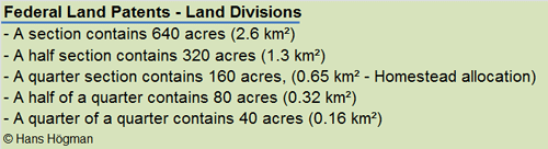
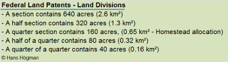
Homestead claims were made based on the rectangular survey system. This system surveys and organizes land based on the 640-acre section, also known as one square mile. The 160 acre homestead comprised one quarter-section of a square mile.States were divided into townships containing 6 square miles and subdivided into 36 sections, each containing 640 acres. Sections were further subdivided into half sections, quarter-sections, and sixteenth-sections or into lots, until the piece of land was accurately described.Township:A township is a major subdivision of the public lands under the rectangular system of surveys. It is a tract of land contained within the boundaries of the north-south range lines. Most townships are 4-sided, measuring approximately 6 miles (10 km) on each side and containing approximately 36 square miles, or 23,040 acres (100 km²).A township is divided into a number of sections. Section:A section is a regular tract of land, 1-mile square, containing 640 acres (2.6 km²), within a township. It is approximately 1/36 of a township.Each section is divided into quarters of 160 acres or approximately 0.65 km² (65 ha). Aliquot Parts are a notation used by the rectangular survey system to represent the exact subdivision of a section of land. Aliquot parts are described as a half or quarter of the largest subdivision of the section, except fractional lots which cannot be described by aliquot parts.Sections subdivided into halves are represented as N, S, E, and W (such as "the south half of section 8") or quarters of a section are represented as NW, SW, NE, and SE (such as "the southwest quarter of section 8").Sometimes, several Aliquot Parts are required to accurately describe a piece of land. For example,"E½ SW¼" denotes the east half of the southwest quarter (containing 80 acres), and "SW¼NE¼NE¼" denotes the southwest quarter of the northeast quarter of the northeast quarter (containing 10 acres).
The Emigration from Sweden to the USA (5a)
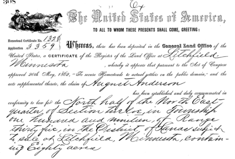
The image above shows the upper part of a Land Patent document from 1873 for the Swedish settler August Anderson, Kandiyohi County, Minnesota. His claim is located in the north half of the northeast Quarter of Section 12 in Township 119 N, Range 35 W and comprised circa 80 acres.As can be seen, this land patent document was created under the Homestead Act of 1862.
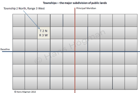
Survey townships are generally referred to by a number based on the Public Land Survey System (PLSS). A survey township is simply a geographic reference used to define property location for deeds and grants as surveyed and platted by the General Land Office (GLO).A reference to a township will look something like "Township 2 North Range 3 East".States were divided into townships in tiers north or south of a horizontal baseline. A baseline is the true east-west line (on a parallel of latitude) extending from an initial point in both directions. The tier stretches in an eastward or westward direction of a vertical principal meridian (an imaginary north-south line) such as Township 24N (24 North).Range: A row or tier of townships lying east or west of the principal meridian and numbered successively to the east and to the west from the principal meridian, such as Range 20W (20 West).A full description of a homestead claim would then be, for example, NE¼NE¼ Sec. 10, T. 2 N., R. 3 W., Fifth Principal Meridian, Minnesota, that is the northeast fourth of the northeast quarter in section 10 of township 2 north and range 3 west. The meridian in this description is based on the 5th Minnesota principal meridian.
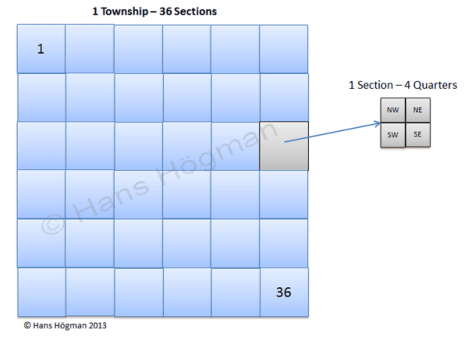
Image above, Subdivision of public lands into Townships. The Township direction indicates which side (north or south) of the baseline the township is on. Range is a tier of townships lying east or west of the principal meridian and numbered successively to the East and to the West from the principal meridian.In the example left, Township 2 North, Range 3 West: North indicates the Township direction from the (horizontal) baseline and West the direction from the principal meridian (vertical).Most Townships are 4-sided, measuring approximately 6 miles (10 km) on each side and containing approximately 36 square miles, or 23,040 acres (100 km²).
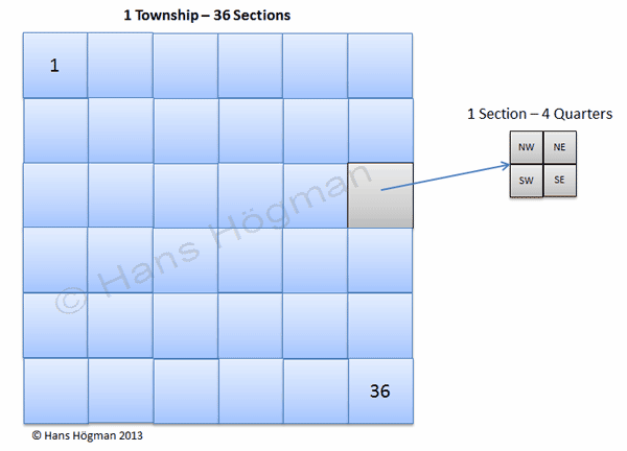
Above, Subdivision into Sections and Quarters.Each Township is subdivided into 36 Sections, 1-mile square, containing 640 acres (2.6 km²). Each section is further subdivided into Quarters of 160 acres or approximately 0.65 km² (65 ha) represented as NW, SW, NE, and SE.
Different types of Land Patents
There were different types of Land Patents. The land patent most interesting for genealogists is the Homestead land patents. Below is a list of the most common types of land patents.•Homestead: A Homestead allowed settlers to apply for up to 160 acres of public land if they lived on it for five years and proof of cultivation. This land did not cost anything per acre, but the settler did pay a filing fee.•Military Warrants: From 1788 to 1855 the United States granted military bounty land warrants as a reward for military service. These warrants were issued in various denominations and based upon the rank and length of service.•Cash Entry: An entry that covered public lands for which the individual paid cash or its equivalent. •Credits: These patents were issued to anyone who either paid by cash at the time of sale and received a discount; or paid by credit in installments over a four-year period. If full payment was not received within the four-year period, title to the land would revert back to the Federal Government. •Indian Patents: Under the general Allotment Act of February 8, 1887, and certain specific laws for named tribes, allotments of land on reservations were made to individual Native Americans residing on the land. There are two kinds of patents that allowed resale by the Native Americans.•Railroad: To aid in the construction of certain railroads. The Act of September 20, 1850, granted to the State alternate sections of public land on either side of the rail lines and branches.•State Selection: Each new State admitted to the Union was granted 500,000 acres of public land for internal improvements established under the Act of September 4, 1841.
Land Patent Documents
The primary identification numbers are located in the upper left-hand corner of the document, e.g. a document number.Patentee names are shown in various areas of the patent. In instances where the patentee was not the original purchaser of the land, the patent will state the purchaser as the Assignee, heirs, and devisees. Military warrants will have the name, rank in service, and a regiment they were affiliated with. These patents were issued in favor of the Officers and Soldiers for their service in the Military, but were often assigned to their heirs or other individuals.Legal Land Descriptions are described in numbered townships in tiers north and south of the base line and ranges east and west of the principal meridians. Townships are subdivided into 36 sections with typical land entries containing 40 to 320 acres. They are described into aliquot parts like quarters. Land descriptions uniquely identify the parcel or parcels of land for which title is given by the land patent.Signature and Date will reflect the President of the United States of America in office at the time and located at the bottom of the document.Land Office:The name of location (usually a city or a town) where the General Land Office established a district land office to handle various land transactions. Usually, several Land Offices existed for each state. Land Offices were established in the district handling the land transactions. They would frequently move and close within the States as the land within their jurisdiction began dwindling.
Land Patent from 1854
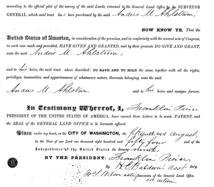
The image above shows the lower part of a Land Patent document from 1854 for the Swedish settler Anders M. Ahlstrom, Stillwater Chisago County, Minnesota. The document is signed August 15, 1854.
Land Patent from 1873
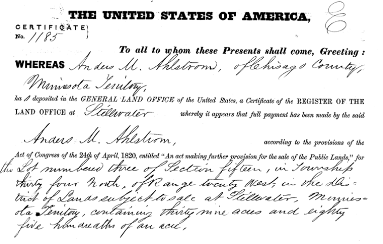
The image above shows the upper part of a Land Patentdocument from1854 for the Swedish settler Anders M. Ahlstrom, Stillwater Chisago County, Minnesota. His claim is located in Lot no 3 of Section 15 in Township 34 N, Range 20 W and comprised circa 39 acres.
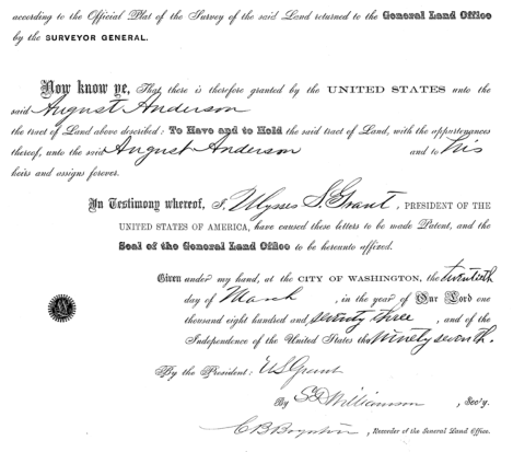
The image above shows the lower part of a Land Patent document from 1873 for the Swedish settler August Anderson, Kandiyohi County, Minnesota. The document is signed March 20, 1873.
During the 19th century there were large amounts of unused arable federal land in the USA, land that wasn’t cultivated. To speed up the colonization westward the US Federal Government gave land to settlers willing to cultivate and live on an allotted piece of land (so-called homesteads). This was regulated in several United States federal laws called Homestead Acts.The land acreage cultivated by settlers constantly expanded westwards. The expansion westward was slow in the beginning but sped up after the Homestead Act of 1862 when homestead land was granted for free. During the large peak of immigration from Sweden, 1865 – 1873, there were still free homestead lands available in the Upper Mid-West. States such as Illinois, Wisconsin, Iowa and above all Minnesota became areas where the Swedish immigrants to the USA settled.
Homestead Acts
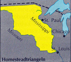
The Homestead Acts were several United States federal laws that gave an applicant ownership of land, typically called a "homestead", at low or no cost. The distribution of Government lands had been an established practice since the Revolutionary War. One of the early homestead ordinances dates back to 1841 (The Preemption Act of 1841). This ordinance consisted of grants totaling 160 acres (65 hectares, or one-quarter section) of unappropriated federal land within the boundaries of the public land states. This land was sold to applicants for 1.25 dollars per acre (1 acre is about 4,000 m2).The most well-known act is the Homestead Act of 1862. This act was signed into law by President Abraham Lincoln on May 20, 1862. Anyone who had never taken up arms against the United States government, was 21 years or older, or the head of a family, could file an application to claim a free federal land grant. There was also a residency requirement and a small registration fee.The occupant of homestead land had to reside on the land for five years, and show evidence of having made improvements like clearing the land and cultivating the ground. There was no need to be a citizen, immigrants also could claim land. Under the Homestead Act, the head of a family could lay claim to up to 160 acres [65 hectares = 0.65 km2, for example an area of about 800 x 810 m (875 x 886 yd.)] of surveyed Government land.The homestead acquisition was a three-fold process:1. Filing an application to claim a free federal land grant2. Living on and improving the land3. Filing for deed of title (land patent) for the land after 5 yearsSo, after 5 years, the homesteader could file for his patent by submitting proof of residency and the required improvements to a local land office.Six months after the Homestead Act was passed, the Railroad Act was signed, and by May 1869, a transcontinental railroad stretched across the frontier.The large railroad companies sold excess land to the settlers. When the railroads progressed westward the railroad companies were granted land by the Government, more land than needed for the tracks. It could be up to 15 - 20 km (15 miles) on both sides of the tracks; therefore they sold excess land to settlers and thereby were able to further finance their projects. The railroad companies were interested in getting communities to grow alongside the tracks and thereby attract passengers to the trains. The new railroads provided easy transportation for homesteaders.The Timber Culture Act of 1873 granted up to 160 acres of land to a homesteader who would plant at least 40 acres of trees over a period of several years. This quarter-section could be added to an existing homestead claim, offering a total of 320 acres to a settler.The distribution of Government lands was intended to promote homestead settlements in the Midwest and the Western United States. The goal was to attract more immigrants and to increase the number of farmers cultivating their own land. Poor immigrants were tempted by these offers. The news about the Homestead Act of 1862 and the free land grants soon reached Sweden. The homestead lands were not bad lands either. In the 1860’s when the area east of the Mississippi River was already developed and cultivated, this land could only be achieved through purchase from private owners at high prices. However, homestead land was available west of the Mississippi River and it was this area that now attracted the immigrants. The best soil lay in the triangle between the main branch of the Mississippi River and its tributary the Missouri, the so-called Homestead Triangle. See image to the right, Emigrantinstitutet, Växjö, Sweden.During the Swedish mass emigration period until the 1890’s homestead land was still available. This was in many cases the decisive reason to emigrate to the United States. The many “American letters” sent back home were an important influence. The Swedish emigrants often wrote in enthusiastic words about the many opportunities in their new homeland. The possibilities of buying emigrant tickets in the United States to be sent back home facilitated the emigration for family and friends.Only 40 percent of the applicants who started the process were able to complete it and obtain title to their homesteaded land. Claims not “proved up” (meaning that the homesteaders on them did not complete the ownership requirements and receive title to the property) were known as relinquishments. When a homesteader relinquished his or her claim, it reverted back to active control of the United States government. Most relinquishments were opened back up to homesteading, and many new settlers moved onto relinquished claims in hopes of finding homes already built, trees cleared, wells dug, or crops planted.Between 1862 and 1934, the federal government granted 1.6 million homesteads and distributed 270,000,000 acres (420,000 sq mi or 1,087,795 km2) of federal land for private ownership. This was a total of 10% of all land in the United States.
Federal Land Patents
Land Patents are Federal Conveyance Documentscreated on the initial transfer of land titles from the Federal government to individuals.Patentee names are shown in various areas of the patent. The primary identification numbers are located in the upper left-hand corner of the document. Legal Land Descriptions are described in numbered townships in tiers north and south of the base line and ranges east and west of the principal meridians. Townships are subdivided into thirty-six sections with typical land entries containing 40 to 320 acres. They are described into aliquot parts. Land Offices were established in the district handling the land transactions. They would frequently move and close within the States as the land within their jurisdiction began dwindling.
The Rectangular Survey System
Homestead claims were made based on the rectangular survey system. This system surveys and organizes land based on the 640-acre section, also known as one square mile. The 160 acre homestead comprised one quarter-section of a square mile.States were divided into townships containing 6 square miles and subdivided into 36 sections, each containing 640 acres. Sections were further subdivided into half sections, quarter-sections, and sixteenth-sections or into lots, until the piece of land was accurately described.Township:A township is a major subdivision of the public lands under the rectangular system of surveys. It is a tract of land contained within the boundaries of the north-south range lines. Most townships are 4-sided, measuring approximately 6 miles (10 km) on each side and containing approximately 36 square miles, or 23,040 acres (100 km²).A township is divided into a number of sections. Section:A section is a regular tract of land, 1-mile square, containing 640 acres (2.6 km²), within a township. It is approximately 1/36 of a township.Each section is divided into quarters of 160 acres or approximately 0.65 km² (65 ha). Aliquot Parts are a notation used by the rectangular survey system to represent the exact subdivision of a section of land. Aliquot parts are described as a half or quarter of the largest subdivision of the section, except fractional lots which cannot be described by aliquot parts.Sections subdivided into halves are represented as N, S, E, and W (such as "the south half of section 8") or quarters of a section are represented as NW, SW, NE, and SE (such as "the southwest quarter of section 8").Sometimes, several Aliquot Parts are required to accurately describe a piece of land. For example,"E½ SW¼" denotes the east half of the southwest quarter (containing 80 acres), and "SW¼NE¼NE¼" denotes the southwest quarter of the northeast quarter of the northeast quarter (containing 10 acres).
The Emigration from
Sweden to the USA (5a)
Survey townships are generally referred to by a number based on the Public Land Survey System (PLSS). A survey township is simply a geographic reference used to define property location for deeds and grants as surveyed and platted by the General Land Office (GLO).A reference to a township will look something like "Township 2 North Range 3 East".States were divided into townships in tiers north or south of a horizontal baseline. A baseline is the true east-west line (on a parallel of latitude) extending from an initial point in both directions. The tier stretches in an eastward or westward direction of a vertical principal meridian (an imaginary north-south line) such as Township 24N (24 North).Range: A row or tier of townships lying east or west of the principal meridian and numbered successively to the east and to the west from the principal meridian, such as Range 20W (20 West).A full description of a homestead claim would then be, for example, NE¼NE¼ Sec. 10, T. 2 N., R. 3 W., Fifth Principal Meridian, Minnesota, that is the northeast fourth of the northeast quarter in section 10 of township 2 north and range 3 west. The meridian in this description is based on the 5th Minnesota principal meridian.
The image above shows the lower part of a Land Patent document from 1854 for the Swedish settler Anders M. Ahlstrom, Stillwater Chisago County, Minnesota. The document is signed August 15, 1854.
Land Patent from 1873
The image above shows the upper part of a Land Patentdocument from1854 for the Swedish settler Anders M. Ahlstrom, Stillwater Chisago County, Minnesota. His claim is located in Lot no 3 of Section 15 in Township 34 N, Range 20 W and comprised circa 39 acres.
Above, Subdivision into Sections and Quarters.Each Township is subdivided into 36 Sections, 1-mile square, containing 640 acres (2.6 km²). Each section is further subdivided into Quarters of 160 acres or approximately 0.65 km² (65 ha) represented as NW, SW, NE, and SE.
Different types of Land Patents
There were different types of Land Patents. The land patent most interesting for genealogists is the Homestead land patents. Below is a list of the most common types of land patents.•Homestead: A Homestead allowed settlers to apply for up to 160 acres of public land if they lived on it for five years and proof of cultivation. This land did not cost anything per acre, but the settler did pay a filing fee.•Military Warrants: From 1788 to 1855 the United States granted military bounty land warrants as a reward for military service. These warrants were issued in various denominations and based upon the rank and length of service.•Cash Entry: An entry that covered public lands for which the individual paid cash or its equivalent. •Credits: These patents were issued to anyone who either paid by cash at the time of sale and received a discount; or paid by credit in installments over a four-year period. If full payment was not received within the four-year period, title to the land would revert back to the Federal Government. •Indian Patents: Under the general Allotment Act of February 8, 1887, and certain specific laws for named tribes, allotments of land on reservations were made to individual Native Americans residing on the land. There are two kinds of patents that allowed resale by the Native Americans.•Railroad: To aid in the construction of certain railroads. The Act of September 20, 1850, granted to the State alternate sections of public land on either side of the rail lines and branches.•State Selection: Each new State admitted to the Union was granted 500,000 acres of public land for internal improvements established under the Act of September 4, 1841.
Land Patent Documents
The primary identification numbers are located in the upper left-hand corner of the document, e.g. a document number.Patentee names are shown in various areas of the patent. In instances where the patentee was not the original purchaser of the land, the patent will state the purchaser as the Assignee, heirs, and devisees. Military warrants will have the name, rank in service, and a regiment they were affiliated with. These patents were issued in favor of the Officers and Soldiers for their service in the Military, but were often assigned to their heirs or other individuals.Legal Land Descriptions are described in numbered townships in tiers north and south of the base line and ranges east and west of the principal meridians. Townships are subdivided into 36 sections with typical land entries containing 40 to 320 acres. They are described into aliquot parts like quarters. Land descriptions uniquely identify the parcel or parcels of land for which title is given by the land patent.Signature and Date will reflect the President of the United States of America in office at the time and located at the bottom of the document.Land Office:The name of location (usually a city or a town) where the General Land Office established a district land office to handle various land transactions. Usually, several Land Offices existed for each state. Land Offices were established in the district handling the land transactions. They would frequently move and close within the States as the land within their jurisdiction began dwindling.
Land Patent from 1854
The image above shows the upper part of a Land Patent document from 1873 for the Swedish settler August Anderson, Kandiyohi County, Minnesota. His claim is located in the north half of the northeast Quarter of Section 12 in Township 119 N, Range 35 W and comprised circa 80 acres.As can be seen, this land patent document was created under the Homestead Act of 1862.
The image above shows the lower part of a Land Patent document from 1873 for the Swedish settler August Anderson, Kandiyohi County, Minnesota. The document is signed March 20, 1873.
Image above, Subdivision of public lands into Townships. The Township direction indicates which side (north or south) of the baseline the township is on. Range is a tier of townships lying east or west of the principal meridian and numbered successively to the East and to the West from the principal meridian.In the example left, Township 2 North, Range 3 West: North indicates the Township direction from the (horizontal) baseline and West the direction from the principal meridian (vertical).Most Townships are 4-sided, measuring approximately 6 miles (10 km) on each side and containing approximately 36 square miles, or 23,040 acres (100 km²).