
Copyright © Hans Högman 2022-01-02


Road Maintenance Obligation
In King Magnus Eriksson's nationwide National Law
Code and Town Law from the 1350s, there were also
laws for the maintenance of Sweden's roads. Under
the Provincial Act's Agriculture code, farmers were
obliged to maintain the road network. Special
division lists were introduced where each stretch of
road was divided into different road lots, and each
of these road lots was to be maintained by the
landowning peasants along the respective road.
In order to keep track of the boundary between the
different road lots, the farmers set up special road
maintenance stones (Swe: väghållningsstenar) at
each end of the allotted lots. These stones were
often marked with the name or initials of the farmer
and the farm.
It also happened that a farmer could have road lots
in several places in his parish, i.e. the lots did not
have to be next to each other.
The landowning farmers were thus obliged to
maintain the roads, i.e. the mantal-set land, and the
roads had to be maintained twice a year, usually
before the spring sowing and after the autumn
harvest. Road maintenance was checked annually by
special road and bridge inspections.
The Swedish National Land Survey Agency (Swe:
Lantmäteriet) was established in 1628 and the land
surveyors carried out road division assignments.
The medieval National Law Code stipulated that the
road width for highways and district roads should
be 10 Swedish cubits (6 m) and for village roads 6
cubits (3.6 m).
The farmers were thus obliged to keep the road
passable over their own land. However, those who
did not have a road across their land did not escape
participating in the road maintenance effort.
Farmers' Road Maintenance Obligation Ends
For centuries, the farmers had complained about
the obligation to maintain roads, and the Peasantry
at the Diet of the Four Estates complained about
this. The burden was gradually distributed so that it
also came to rest on divided off agricultural
property, but also on other taxable property. A new
organization of the road system was created and
came into force in 1895 with so-called road
municipalities, which were also based on municipal
autonomy. The new road municipalities, divided into
different road districts, usually covered an entire
court district.
The road municipalities were a kind of municipality
with its own levying right, an administrative road
board (Swe: vägstyrelse), and a decision-making road
council (vägstämma). Every taxpayer had access to
the road council meeting and the right to vote. Like
municipal voting rights, this was graduated, i.e.
voting was based on income and property value
based on "fyrktal". Agricultural properties were still
obliged to carry out road maintenance but had a
lower estimated road tax per fyrk. The roads within
the road district were divided into sections according
to the assessed value of the farm, and the sections
were marked with road signs following the roads. An
innovation was that the Government provided a
subsidy for road maintenance of 10% of the
estimated cost.
A change in the law in 1921 gave the road
maintenance districts the right to carry out all in-
kind road maintenance through the road board. The
medieval burden placed solely on the land was thus
finally removed.
Northern Trail (Norrstigen)
Along the Norrland coast, there was a well-known
route, Norrstigen (The Northern Trail). It was to be
cleared to a width of 6 cubits (3.6 m). In the Middle
Ages, there was hardly any roadway to speak of, as
wheel carts were not used. But roads had to be
provided to the parishes inland for their connection
to the trail. These roads (paths) were of a lower
standard than the Norrstigen.
For the farmers who maintained the roads, it was of
course a heavy burden to build and maintain these
roads. But both judges and local police officers
checked that the roads were passable and
prosecuted any negligent road-keepers.
Norrstigen later came to be known as
Kustlandsvägen (The Coast Highway). During the
20th century, the Stockholm-Haparanda section was
renamed Riksväg 13 (National Road 13). Nowadays
this stretch is part of the E4 (European Road 4).
Ådalsvägen (Ådalen Route) was a detour from the
Northern Trail, which followed the Ångerman River
from its estuary up towards Sollefteå town.
1500s
In 1559, King Gustav Vasa decreed which roads
between the counties should be the main roads and
they should be widened to roads that could be used
by horses and wagons. The old riding paths should
be cleared, widened, straightened and the road
surface leveled. However, the work was slow, the
roads continued to be stony and rough. But it was at
this time that roads began to be built in contrast to
the old natural paths. Stone-filled caissons were
used for longer wooden bridges over watercourses.
Roads were now generally laid at the boundaries
between estates and often in the area between
woods and fields, winding around fields and
meadows across the landscape.
1600s
During the days of Sweden’s Great Power Era, there
was a considerable increase in the demand for
passable roads, roads that could also serve as
marching routes for the army with its heavy horse
and carriage transport.
In 1628, the newly established National Land Survey
Agency began to measure and map the roads. These
maps were considered military secrets at the time.
Under the Constitution of 1634, Sweden was
divided into counties, with a County
Administrative Board (Swe: Länstyrelse) in each
county. With the creation of the County
Administrative Boards, road management was
improved. However, road work was primitive and
was done by hand with shovels, pickaxes,
wheelbarrows, horses, etc. Bridges were usually built
of wood, but pontoon bridges also existed.
Queen Kristina's Innkeepers' Ordinance of 1649
included rules for inns to be established every 20 km
(12 mi) and milestones to be erected along the
roads at every 10 km (6 mi). The roads were to be
measured so that all 10 km stretches were of equal
length. The county governors were given the task of
ensuring that the road maintenance obligation was
fulfilled. The governors were also responsible for the
erection of milestones.
At county and parish borders, there were sometimes
so-called rightly stones (Swe: rättestenar) urging
travelers to behave lawfully.
Road policy in the 17th century was mainly to
improve the standard of the existing roads; the
simple hoof paths were to be improved to become
cart paths and the cart paths were to be
transformed into almost stone and hill free carriage
roads.
1700s
The 18th century was a time of road building. Many
works were established in the 18th century and the
need for roads for transport increased dramatically,
and in all months of the year. Demands on roads
increased and existing roads were improved and
new ones were built. The demand for faster travel,
better carts that could carry larger loads, etc.,
contributed in the following century to a lot of work
being done to remove the worst uphills and, above
all, to improve the road surface.
In 1718 Sweden receives a decree on right-hand
traffic, but under the 1734 Law, left-hand traffic
was introduced. It also included an ordinance on
signposting to communities and clarifications on
road maintenance.
In the 1734 Act, the Agriculture Code (Swe:
Byggningabalken) provides, among other things, for
the division of roads into public roads, church
roads, mill roads, and village roads. A chapter
deals with road maintenance and the conditions for
building roads, as well as the obligation to clear and
maintain roads and bridges and “road shall be laid in
the County where it is needed”. There is also text on
milestones and signposting. Concerning winter road
maintenance, there is only mention of winter roads
on ice, but nothing about snow clearance.
The medieval National Law Code stipulated that the
road width for highways and court roads should be
10 Swedish cubits (6 m) and for village roads 6 cubits
(3.6 m). As for road width in the 18th century, these
measurements are repeated in the Agriculture Code
in the 1734 Act. This law was in force until the 1891
Road Act, which stipulated a road width of 6 m for
highways and 3.6 m for village roads.
{A Swedish cubic (aln) = 59 cm}
It was not until the middle of the 18th century that
the major highways could be said to be in such good
condition that, with some difficulty, it was possible to
travel on them by horse and carriage. In 1752 it was
decided that stone bridges should be built on public
roads, so-called arch bridges. Although the roads
were still poor, Sweden, with its solid bedrock, still
had relatively good roads internationally.
However, the bulk of long and heavy haulage has
traditionally taken place mainly in winter with snow
conditions and especially on winter roads over the
ice.
1800s
The introduction of a central government agency
for the road system was brought up by Captain Axel
Erik von Sydow in a small publication "The benefits
and necessities of public work" in 1840. The proposal
aroused great interest among King Karl XIV Johan
and was the subject of a royal decree on August 6.
In 1841, the "Royal Board for Public Road and Water
Construction" was established, i.e. what later became
the National Road Administration (Swe: Vägverket).
The name "Royal Board for Public Road and Water
Construction" changed in 1882 to the Royal Road and
Water Construction Board (Kungl. väg- och
vattenbyggnadsstyrelsen).
Initially, and well into the 20th century, the Agency's
responsibility was only to allocate government
grants for the construction of roads, bridges, and
canals, and to check that the work had been carried
out properly. It was still the responsibility of the
farmers to carry out the actual construction of
the roads and to maintain them.
In the 19th century, the roads face competition from
both steamship traffic and the railways in terms of
travel. In 1832, the Göta Canal was completed,
enabling both passenger and freight travel across
Sweden. To improve and to make the roads more
passable, macadam (crushed gravel) is laid on the
road surface to make it more durable and less
muddy.
With the expansion of the railroad in the second
half of the 19th century, roads were also built to the
new station communities growing around the
railway stations.
In 1891, Parliament passed a new Road Act, which
came into force in 1895. Under the new Act, road
maintenance obligations were distributed according
to the assessed values of all rural properties. The
landowning farmers were no longer solely
responsible for maintaining the roads. Each
landowner who was obliged to maintain a road was
given a certain number of road lots to maintain in
proportion to the size of the property. At the end of
the 19th century, there were about 360.000 road lots
in the country.
Sweden was divided into 368 road maintenance
districts, which were usually made up of the
respective parish, county district, or court district.
The 1891 Road Act established the old road width of
6 m for highways and 3.6 m for village roads.
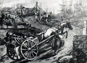
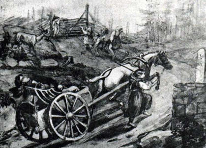
The image shows travelers with a horse and cart in
Småland province, Sweden. Drawing by Fritz von
Dardel (1817-1901). The image also shows a
milestone and a closed gate across the road.
Road Gates
In the past, there could be gates even on public
roads, gates that had to be opened and closed by
the person passing the gate. In 1857, the County
Administrative Board decided that the gates should
be removed during the seasons when they were not
needed for livestock. In 1864 it was forbidden to put
up a gate across the road without the permission of
the County Administrative Board, this applied to
highways and county district roads. In 1927, a
general ban on gates on public roads was
introduced.
1900s
At the beginning of the 20th century, motoring is on
the increase with more traffic on the roads. This
meant that the old medieval road management
could no longer meet the new demands on roads.
Instead, a road tax (Swe: vägskatt) was introduced
and road maintenance was taken over by road
funds (Swe: vägkassor), one for each road
maintenance district. The road funds received
financial resources in the form of road taxes and
government grants. The road boards (vägstyrelser),
which managed the road funds, employed road
engineers and road workers.
In 1922, Parliament decided to introduce an
automobile tax. The tax, which initially went directly
to road maintenance, was distributed to both urban
and rural areas by the Royal Road and Water
Construction Board (Swe: Kungl. väg- och
vattenbyggnadsstyrelsen). From 1924, the County
Administrative Boards could also employ road
consultants.
In the 1934 Road Act, roads are divided into
highways and rural roads. No provision is made for
road widths.
In 1937, the old natural road maintenance system
was completely abolished and the former 368 road
maintenance districts were merged into 170 road
districts. Road maintenance could now be carried
out more efficiently, including with the help of
machinery, but road maintenance was still a
municipal affair.
On 1 January 1944, roads and road maintenance in
rural areas were nationalized. The agency
responsible for central administration became the
Royal Road and Water Construction Board. Road
administrations were now established in each
county.
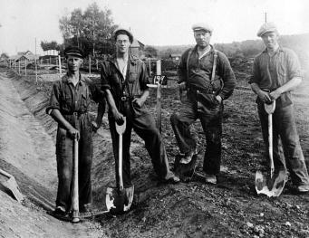
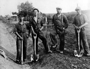
During the high unemployment of the 1920s and
1930s, many new roads were built in an effort to
keep unemployment down. It was the Government
Unemployment Commission (Swe: Statens
Arbetslöshetskommission, AK) that organized this
construction.
The image to the
right shows a
road
construction
between
Alingsås-
Vårgårda in 1933
with so-called
AK workers.
Photo: Alingsås
museum, ID:
AMB 15908.
Road Surfacing
According to the old provincial laws, roads and
bridges had to be inspected every year. It was
customary to gravel the road just before the
inspection. Graveling was prescribed in 1734 when
the road keepers were given access to gravel pits.
The natural gravel then used as road surface
material was later out-competed by crushed gravel.
In 1953 it ceased to be used altogether.
In 1854, macadam was laid on the road between
Malmö and Lund, after which this water-bound
macadam surfacing came into use in Sweden.
The first Swedish asphalting of a road was done in
1876 on the street "Stora Nygatan" in Stockholm.
The first asphalting of a highway in Sweden was
probably carried out in the Stockholm area in 1909,
using macadam and a bituminous binder. The length
of road paved increased rapidly until the outbreak of
World War II when there was a shortage of
bituminous binder. In the late 1950s, roads also
began to be paved with oil gravel.
In 1906-1907, concrete paving was laid on some
streets in Malmö, southern Sweden. The first
concrete pavement on a highway in Sweden was laid
in 1923 on a 400 m stretch of road between
Stockholm and Södertälje. During the post-war
period, several roads in Sweden were paved with
concrete. The first concrete-surfaced motorway was
opened in 1953 between Malmö and Lund. Concrete
roads are not common in Sweden and today there is
just under 70 km of concrete roads.
Bridges
The term bridge does not only refer to cantilever
structures but in general to any kind of built-up road
or road bank. They were usually built over the banks
of the river at ford sites. Medieval provincial laws
contain information on bridge building and
maintenance.
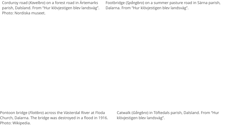
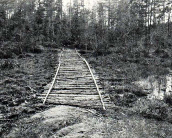
Wooden Bridges
The simplest wooden bridges were so-called
corduroy roads (Swe: kavelbro), which are a
reinforcement for simple roads over marsh ground.
They consist of logs laid close together across the
direction of the road, like sleepers on a railway. The
logs distribute the load of a vehicle's weight and
prevent it from sinking into the ground, and they
were laid directly on the marshy ground.
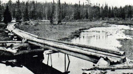
The most common type of actual wooden bridge
was some form of beam bridge (Swe: balkbro).
Sometimes high wooden abutments were built, such
as stone-filled timber caissons. Stone-filled timber
caissons were also used in the water for longer
bridges.
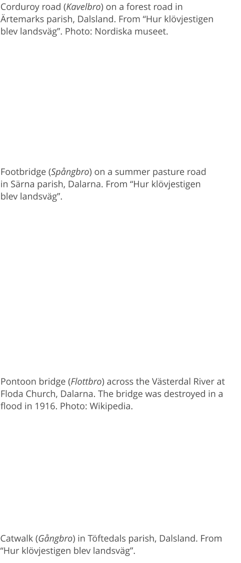
A special type of wooden bridge was the pontoon
bridge, (Swe: flottbro), which was especially common
in the Dalälven River. A pontoon bridge is a special
type of bridge where the roadway is supported by
rafts, which float on the water.
Related Links
•
Road History, page-2, Terminology
•
Inns and Stage Services
•
Summer Pasture
•
The Conception of Socken (parish)
•
Domestic Travel Certificates
•
History of the Swedish Police
•
History of Railways in Sweden
•
History of Göta Canal
•
Old Swedish Units of Measurement
•
Agricultural Land Reforms, Sweden
Source References
•
Vägen i kulturlandskapet, vägar och trafik före
bilismen, Vägverket, 2004
•
Det gamla Ytterlännäs, Sten Berglund, 1974.
Utgiven av Ytterlännäs hembygdsförening.
Kapitel 39, sid 368 och framåt.
•
Hur klövjestigen blev landsväg, Gösta Berg, 1935.
(Svenska kulturbilder / Första utgåvan. Andra
bandet (del III & IV), sid 269 och framåt.)
•
Gästgiveri och skjutshåll, Ur det forna reselivets
krönika, av Sven Sjöberg. Ur årsboken Uppland,
1959.
•
Stigen av Lars Levander, 1953
•
Svenska Akademins Ordbok, SAOB (Swedish
Academy Dictionary)
•
Wikipedia
•
Lantmäteriet (The National Land Survey of
Sweden)
Top of page
Swedish Road History (1)
Stone Bridges
The oldest stone bridges were simple stone beam
bridges (Swe: Stenbalkbro) with a very limited span.
They consisted of one or more flat cut stones resting
on stone abutments.
From the end of the 18th century and for most of the
19th century, the most common type of arched
bridge was built of wedged stone in a dry stonewall,
i.e. without mortar. At the end of the 19th century,
mortar began to be used as a binding agent. At that
time, stone arch bridges (Swe: Stenvalvbro) were
usually built of smooth-cut stones and stone arch
bridges were built until the 1930s.
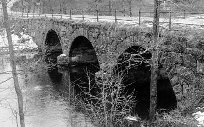
According to a royal decree of 1752, all bridges built
with public funds had to be made of stone.
The image shows a stone arch bridge in Lerum.
Photo: Vänersborg Museum, ID: VMLER0030.
Iron Bridges
The first iron bridge built in Sweden crossed the
Göta Canal and was built in 1813 in Forsvik,
Västergötland. In the beginning, cast iron was used. It
was not until the 1880s that steel road bridges
became common. Until the 1920s, when concrete
rapidly gained ground, this was the predominant
bridge-building material. The most common type of
construction was the beam bridge. However, the
roadway was usually made of wood.
Concrete Bridges
The first concrete bridges built in Sweden were in
1887 at Jordberga and across the Höje River in Lund,
both in Skåne. At the beginning of the 20th century,
concrete bridges became common.
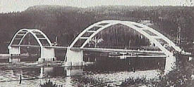
The Skuru bridge in Stockholm was built between
1914 and 1915 and was the first major bridge to be
built in reinforced concrete using modern
construction principles. After this, concrete bridges
began to displace steel bridges even for larger spans.
The image shows
the Haraberg bridge
(concrete bridge)
over the Ljungan
River in Kvissleby,
Njurunda, south of
Sundsvall. Photo: Sundsvall Museum, ID: SuM-
foto013586.
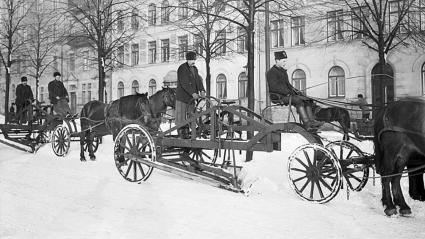
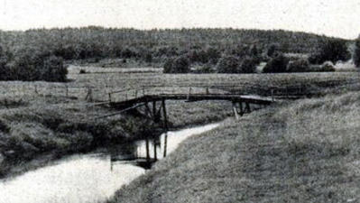
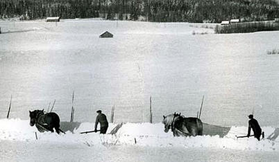
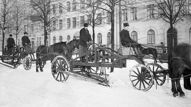
Winter Road Maintenance
In the Middle Ages, there was no regular winter road
maintenance. The snow-covered road surface was
"smoothed down", i.e. the snow was cleared by driving
back and forth with a horse and sled (similar to snow
rolling). In this way, the road became passable. The
first direct mention of winter road maintenance is in
the 1687 county governor's instructions. The governors
were now given the task of ensuring that roads and
bridges were maintained. This did not only apply to
summer roads but also to roads "that are used and
needed in winter".
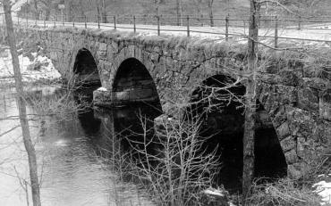
In winter, farmers took it in turns to keep the private
roads open when snow fell. In order to keep track of
who was next to do the snowplowing, there was a
special system without paper and pen. They had a
kind of rallying stick, a so-called plow block or road
stick, on which the name or other owner’s marks of
those who were to be responsible for plowing were
engraved. The person who had made his
snowplowing turn then handed over the piece of
wood to the next person in line.
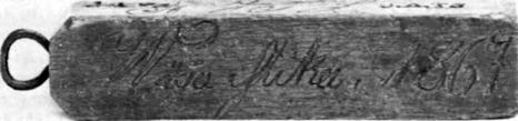
The image shows a plow block (plogklomp) or road
stick (vägsticka) from 1867 in Ytterlännäs,
Ångermanland. Image: Det Gamla Ytterlännäs, page
378.
It was the village councils (Swe: Byalag) that were
responsible for plowing the snow by forming plow
teams (Swe: ploglag) consisting of the landowning
villagers. The public roads within the parish were
divided into lots of different lengths according to the
mantal-set land (Seland in Ångermanland) included in
the plowing team. The entire length of the roads in
the parish was measured, taking into account the
difficulty of plowing different parts of the roads. In
Ytterlännäs parish, Ångermanland, the snow plowing
was regulated in 1866 so that 293.77 feet of the road
were placed on each piece of seland-set land in the
parish. A village or a few homesteads in a village then
formed a plow team whose total number of seland
was multiplied by the above-mentioned figure, which
then became the length of road for which the plow
team was responsible. In total, the whole parish was
divided into 24 plow teams, and at the boundary
between the different plow teams' stretches, a visible
mark was put up.
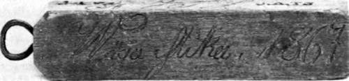
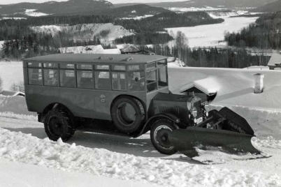
The horse-drawn snowplow is invented in 1730,
shortly followed by the road scraper (grader). In open
landscapes, avenue trees are planted to mark the
road in winter and provide cooling shade in summer.
At the beginning of the 20th century, the so-called
half-plow was introduced. It was easier to handle
and required less traction than the standard wedge-
plow. The half-plow consisted of only one plowing
side, which meant that one half of the road was
plowed at a time. In Lycksele, modern machine
plowing was introduced in 1925. Here the first
Swedish car plow was demonstrated, a front-end
plow called the Lycksele plow.
In Sweden, anti-slipperiness measures in the form
of road sanding (gritting) on highways were first
introduced with car traffic in the 1920s. Gritting was
a difficult balancing act between the different needs
of car and sled traffic. In 1949, the first tests of anti-
slip road salting were carried out in Västmanland.
Introduction
Long ago, roads were not the first choice for travel,
either for long journeys or for journeys with heavy
goods. Waterways were more important, such as the
sea, lakes, and rivers, which were traveled by boat. In
winter, when there was snow and frost on the
ground and the lakes were frozen, the easiest way to
get around was by horse and sled, which allowed the
shortest route to be taken over both land and water.
On land, there was only a need for paths that could
be followed on foot or horseback. At that time, it was
enough to simply clear away obstructing bushes and
branches in the forest. Paths were avoided on the
sunken ground, where temporary obstacles could be
found. Rather, paths were built on hills and dry
ridges.
Where farms or villages were located on
watercourses, it was often easier to get around by
sea.
But as communities grew, there was a need for
better connections between them. The Hälsinge
Provincial Act from around 1320 already mentions
roads, dividing them into public roads and private
roads. The former included the road to the district
court and the church. So, according to the law, there
should be a road to the church, for example. The
obligation to build and maintain public roads and
bridges lay with the landowners, i.e. the resident
peasants. This obligation was later distributed
according to each farmer's landholding, i.e. the
mantal-set land.
It was a fine for neglected road maintenance. In
winter, when the ice had settled, roads on land were
abandoned in many places, and travel took place on
the ice over lakes or by sea. These winter routes were
also regulated by law.
Natural road staking is the oldest variant where the
road follows the natural topography and vegetation.
Often these are old narrow paths that have been
widened and reinforced over the years to form the
road that exists today. These roads are often crooked
in both plan and profile.
In the second half of the 19th century, there were still
many rural villages that lacked access by horse and
cart in the summer. In Ytterlännäs parish in southern
Ångermanland, the villages of Majaån, Västertorp,
and Västansjö had only their footpaths and hoof-
paths to reach the main road to Forsed, where they
had their summer vehicles for the journey down to
the village. It was not until the 1890s that they had a
passable road to the villages. The single farm
Abborrsjön, further to the east, was roadless until
1936.
Paths and Roads
Footpath
A footpath (Swe: gångstig) or path is a narrow route
primarily for pedestrians. Natural paths are
common, especially in wooded areas and other
areas with "natural" ground vegetation. The natural
path has been created by the wear and tear of feet
and perhaps once hooves, which has eroded, worn
down, and removed ground vegetation along a
narrow strip. The presence of the path has then led
to further walkers choosing the same route, thus
preventing it from growing again. The benefits of
choosing an existing path in the woodland are better
access and better wayfinding.
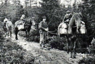
Hoof Path
Transport by a pack-animal (Swe: klövja) means
placing a load on a pack animal, i.e. transporting a
load on the back of a pack animal. The pack
animal might be a horse, donkey, ox, reindeer, etc.
Often special packsaddles or pack bags are used
which hang on both sides of the animal to distribute
the weight evenly. Transport by a pack animal is
particularly used in rough terrain, where wheeled
transport is impossible. A hoof path or hoof trail
(Swe: klövjestig) is a path/road on which goods can
only be transported loaded on hoofed animals, i.e. a
path which is slightly wider than a footpath.
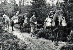
The image shows a
hoofed trail with pack
animals and
packsaddle. Hoof trail
to summer pastures in
Leksand parish,
Dalarna. Photo: From
“How the hoof path
became a road”.
Riding Path/Trail
A trail or path (Swe: ridstig) accessible only to
equestrians; as opposed to a footpath or trafficable
road.
Cart Road
A cart road (Swe: kärrväg) is a type of small road,
often in the woods, used for driving a horse and
cart (single-axle) and other simple wheeled vehicles.
Unlike a hoof path, a cart track could be used for
horse-drawn carts on bare ground, for example by
farmers bringing hay home from their fields. The cart
track is characterized by two-wheel tracks and a
trampled path following the horse's hooves in the
middle of the road. Where there was no cart track,
winter road transport was often the only option for
transporting large quantities of goods.
Wagon Road
Wagon road (Swe: vagnväg); a (constructed) road
with two-wheel tracks that could be traveled by
horse and wagon; also in more special use, if road
for (horse-drawn) wagon transport.
A wagon road is a major cart road capable of running
with a horse and carriage, i.e. two-axle vehicles.
Wagons with wheels allow much higher weight than
carrying the load (of a person or an animal), but only
if there is a road, otherwise a wagon is of no
advantage. A wagon has a superstructure or basket
that rests on two axles (sometimes one axle) and
usually four wheels and can be driven on a wagon
road or highway.
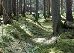
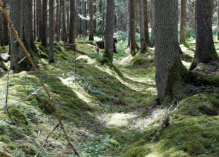
Sunken Lane (Hollow Way)
A sunken lane or hollow way (Swe: hålväg) is a relic
of the past consisting of a furrow in the ground
where an ancient road passed. The furrow has been
formed by the wear and tear of hooves and feet, and
by running surface water.
In slopes and where different paths could converge
towards a ford, there was particularly high wear of
feet and hooves in combination with water erosion.
There, quite deep tracks could gradually dig into the
ground. This type of "road" is called a sunken lane.
Many of these have been preserved. The largest
system of sunken lanes in Sweden is found near
Sandhem Church in Västergötland, where in places
there are over 20
parallel "lanes" of
hollow roads.
The image shows a
hollow way in the
nature reserve
Slereboån Valley near
the village of Röserna
in Risveden,
Västergötland. Photo: Wikipedia.
Highway
A highway (Swe: landsväg) is a major (constructed)
public road overland; a main road, linking two or
more major towns.
“Land” in the Swedish term “landsväg” emphasizes
that it is a road overland as opposed to a waterway.
Village Road
A village road (Swe: byväg) is a road leading from a
public road (usually a highway) to and through one
or more villages or individual farms, i.e. a maintained
minor road.
Church Road
A church road (Swe: kyrkväg) is a local road leading
to a church.
Courthouse Road
A courthouse road (Swe: tingsväg) is a local road
leading to a district courthouse.
National Roads
National road or national highway (Swe: Riksväg)
is a classification of roads that exists in several
countries. The meaning of the classification varies
from country to country, but national roads are often
roads that are considered important for the
country's infrastructure. In Sweden, roads with
road numbers from 1 to 99 are called Riksvägar.
Riksvägar are often of a relatively high standard and
sometimes pass through several counties. They
cover the whole of Sweden.
In Sweden, national roads with low numbers are in
the south and those with high numbers are in the
north. In 1961, the Swedish national highway system
was redesigned. Some former national roads
became European roads and are counted as a
national road with the same number as the European
road, but only the European road number is
displayed on signposts. The remaining national
roads (riksvägar), often with new routes, were re-
signed from 1962 with white numbers against a blue
background.
From 1945 to 1962, the Helsingborg-Stockholm route
was called Riksväg 1. The section to the north, i.e.
Stockholm-Haparanda, became Riksväg 13.
Nowadays this entire stretch is the E4 (Europaväg 4).
Från 1945 till 1962 hette vägen
Helsingborg–Stockholm Riksväg 1 eller Riksettan.
Sträckan norrut, dvs Stockholm–Haparanda blev
Riksväg 13 eller Rikstretton. Numera är hela denna
sträcka E4 (Europe road 4).
Regional Roads
In Sweden, a county road (Swe: länsväg) is a
government-owned public road that is not a National
road or a European road. County roads are divided
into two categories according to their importance:
primary and other county roads.
Primary county roads have a common number series
throughout Sweden and, despite the name, may
cross county borders. Primary county roads are
numbered 100-499 and the number is displayed
along the road. Other county roads have their own
number series in each county, from 500 upwards.
County District Road
In Sweden before 1891, the County district road
(Swe: Häradsväg) was a road of lesser importance
than a highway but greater than a parish road. A
county district road had to be at least 6 Swedish
cubits (3.6 metres) wide, but the distinction between
county district road and parish road was not very
well defined. Under the 1891 Road Act, both the
county district road and the parish road were
replaced by the rural road (Swe: bygdeväg).
Parish Road
A parish road (Swe: sockenväg) is a comparatively
small or narrow public road through a parish, a road
that was paid for by the parish (usually 6 Swedish
cubits wide) and that mainly served the parish's own
needs (as opposed to a highway or a county district
road). In 1895 they were officially replaced by the
rural road.
Rural Road
A rural road (Swe: Bygdeväg) is the Swedish name
for a highway with extra wide shoulders, but only
one narrower lane in the middle for cars. The aim is
to make life easier for cyclists and pedestrians. The
idea is that cyclists and pedestrians should use the
shoulders, and car drivers at meetings should be
able to use the shoulders if necessary.