
Copyright © Hans Högman 2022-01-02
Swedish Road History (2)
Terminology
Village (By)
Village (Swe: By) can denote a named place consisting
of at least two neighboring farms and possibly several
crofts in the countryside, but was also a legal
designation for a collection of farms that are or have
been a community for the common ownership and
use of certain land or forest - so-called commons
(agricultural villages). The latter definition applied
before the land reform of the early nineteenth century
to Swedish and Finnish land parcels shared by several
farms. The term is used primarily to refer to
agricultural villages.
Byaman
Byaman, a person who owns land in a village and
resides there, i.e. landowning villager. (SAOB).
Village Council (Bystämma)
The village council (Swe: Bystämma) was the
institution in which the landowners/shareholders of a
village were organized and the council was headed by
a village elder (Swe: byaålderman or byfogde) who was
appointed by the villagers (the landowners of the
village) to manage the village's activities and the rules
of the villages were written down in a Village
Ordinance (Byordning). The members of the council
are called the “byalag” (or byaråd). These had similar
legal status in terms of voting rights at the village
council. Among other things, the Village Council
appointed the village's representatives to the Parish
Council (Swe: Sockenstämman).
The members of the village council are the villagers
(byamännen, byaman in the singular), i.e. those who
own land in the village (more than one plot) and thus
hold an agricultural property. The village council
governed the village according to customary law, often
codified in a specially written village regulation, a
charter of common affairs issued by the district court.
The village elder is elected by merit or in turn
according to a rotation system.
The village ordinance (Byordningen) regulated
obligations and rights with regard to common
property, management of livestock, etc. After many
villages in Götaland and southern Svealand were split
up following several land reforms in the 18th and 19th
centuries - Storskifte, Enskifte, and Laga Skifte - the
"Byalag" became less important there. In Dalarna,
Hälsingland, Jämtland, and other provinces in central
and northern Sweden, however, most villages
remained intact, and "byalag" has continued to play a
natural role there.
Fyrk
The fyrk was the measure used to indicate voting
strength in rural municipalities. It was calculated
after taxation, and in this respect was a precursor to
today's local tax rate (skattekrona). According to the
1862 municipal laws, the fyrk was calculated as
follows: for the land set in mantal, a whole mantal was
equal to one hundred fyrk, regardless of the tax for
which the land was assessed.
Mantal
The mantal was a measure of a landed property’s
fiscal size (i.e. a homestead's yield), expressed by the
mantal-set value and the basis for the mantal tax.
So, the mantal was a property tax code, a measure of
propertied, which formed the basis for taxation in
Sweden. The mantal was usually calculated in arable
and meadow-land, and was estimated in barrels
(acres) according to how much grain could be grown
on the farmland. Groves and plots were excluded.
So, the mantal-set value was a measure of a
homestead’s fiscal power (based on the yield) and the
tax payments that the homestead had to make.
Originally, the measurements were 1, ½, or ¼.
Homestead distributions due to inheritance and write-
down of the mantal figures (förmedling) gradually led
to shifts in the quotas (to ¾ or ⅛, for example), and
after a few generations of inheritances to very
unwieldy quotas.
In Ångermanland province a similar term was used,
seland. There were 24 seland on one mantal, i.e. one
seland was 1/24 mantal.
The mantalspenningar (the mantal tax) was the tax
based on the number of the mantal-set value of each
homestead, which from 1635 became permanent.
Mantalslängd was a roll of the (taxable) inhabitants
of a district (parish) of those who were obliged to pay
the so-called mantal tax.
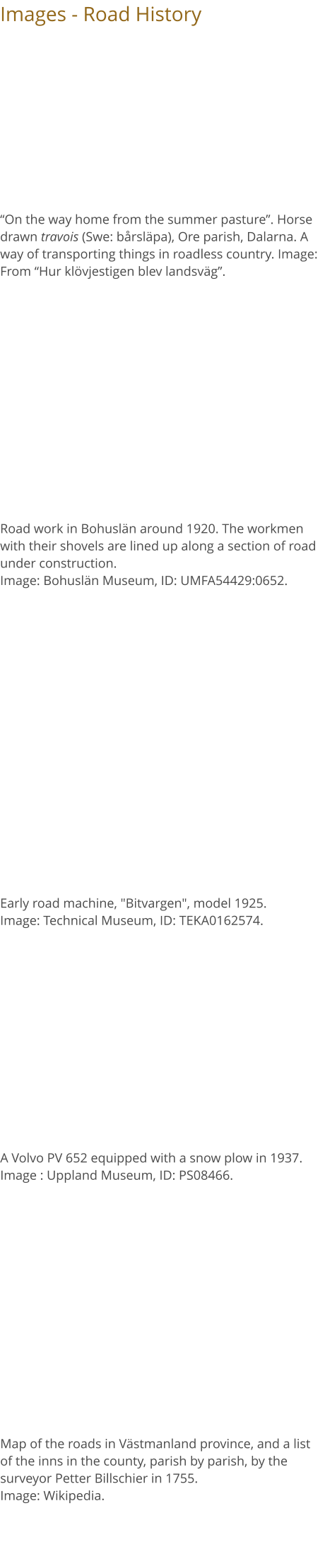
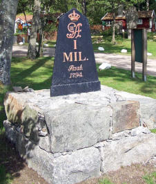
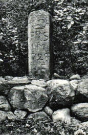
Milestones
A milepost (Swe: milstolpe) or milestone (milsten) is
an early precursor to signposts. In Sweden, milestones
were used from the 1649 Inn Ordinance (Swe:
Gästgivarordning) until the 1890s to mark distances
along highways and later county district roads.
The oldest royal decree on milestones is thus from
1649 and the County Governors became responsible
for the erection of milestones. The milestones could
be used to calculate the length of a journey. Mileposts
were set up according to the Swedish mil system: ¼,
½, ¾ and 1 mil {a Swedish mil was then 10,7 km}.
Between each post, there was a quarter of a mil
(about 2,672 m). It is from this division that the
expression "fjärdingsväg" "a quarter mil" originated.
The milestones were either made of wood or stone.
In the 18th century, the cast iron milestone became
common. The appearance of the milestones varies
from county to county and from time to time. In
addition to the Swedish "mil" markers, the year, the
royal crown, and the county governor's initials are
usually also found on the posts. The milestones were
usually placed in foundations (pedestals) of dry stone
walls. Please note that a Swedish “mil” is not the same
as an English mile.
The Old Swedish Mil was (years 1699 - 1889) = 10,688
meters. The mil was divided into 4 fjärdingsväg
(quarters) of 2,672 meters or 4,500 Swedish cubits
each. In 1889, the current mil of 1 mil = 10 kilometers
(metric mil) was introduced {10 km = 6.2 miles}.
The new Road Act of 1891 (which came into force in
1895) abolished the regulations on the erection of
milestones.
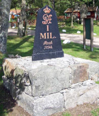
The images show milestones made of wood, stone,
and cast iron respectively. The wooden post is a
quarter pole from Älghult parish, Småland. The stone
milestone is from Dalby parish, Skåne. Both pictures
are from: “Hur klövjestigen blev landsväg”. The cast iron
milestone is from Karlskrona, 1794. Photo 2005.
Image: Wikipedia.
Place Names and Roads
In many place names, information about our oldest
infrastructure can be found directly or indirectly.
Examples of place names that indicate some kind of
worked ford are Örebro, Örsundsbro, and Jordbro.
The word ör- comes from the Old Norse word "aur"
which means, gravel, gravel bank.
Place names with bor in the name indicate that there
was a place where boats were carried or towed past
rapids and shallows, for example Borlänge. Names of
kavel- indicate that there has been a bridge (usually
over a bog or marshland) made of round logs,
kavelbro (Eng: corduroy road). In Kavelmora there was
certainly an old corduroy road. The meaning of a round
wooden piece is also found in the word “brödkavle”
(Eng: rolling pin).
In the past, there was a need to be able to refer to
different sections of a road in order to locate events or
conditions along the way. It could be a hill that had
become impassable due to weather conditions or a
part of the road washed away by rain, etc. It could also
be an assault or the sighting of a wanted person in a
wooded area, etc.
The names of the different road sections were
needed. In Ytterlännäs parish, Ångermanland, there
are examples of some such names: Skarplands
backen, Lägdern, Djupdalsbacken,
Manslagarbackarna, Långman, Molivägaskälet,
Finnsgrinna, Finnsbacken, Angstagrinna,
Bursjövägaskälet, Hästhagen, Lillskola, Hans
Jonsbacken, Kroken, Nybron, etc. Source: The Old
Ytterlännäs.
Names with “backen” being part of the name
indicates that this was part of a road going up a
hillside or slope.
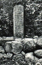
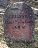
Road Maintenance Stones
Road maintenance stones (Swe: väghållningsstenar)
are markers of varying design that used to be erected
along public roads, indicating the stretch of road that
a road-keeping landowner was obliged to keep in a
passable condition.
Already in the medieval provincial laws, it was
stipulated that the landowning farmers were
responsible for road maintenance in the form of so-
called natural road maintenance
(Swe: naturaväghållning). In order to ensure a fair
distribution of road maintenance obligations, the
National Land Survey (Swe: Lantmäteriet) drew up
special road division rolls in 1628. In these rolls, the
roads were listed and divided into different parts
called road lots (Swe: väglotter). The road lots were to
be maintained by the landowning farmers in
proportion to their landholdings, the mantal-set land.
The road lots were numbered in the rolls and it was
noted which farmer was the road keeper on which lot.
The roads were inspected annually. Farmers who had
not done a good job of maintaining the roads were
then given recorded remarks.
A farmer's road lots could be found in several places
in the parish and in order to know where the different
road lots were located, the farmers put up so-called
road maintenance stones (Swe: väghållningsstenar)
at their respective road lots. These stones were
shaped according to the farmer's own taste. They
were usually made of wood, but sometimes also of
stone. On these posts and stones, they carved the
number of the road lot and its length, and sometimes
also the name or initials of the farmer or farm
(owner’s mark) and the farm's mantal, as well as an
arrow marking the direction in which the
maintenance extended. In 1891, Sweden received its
first Road Act, which came into force in 1895, and
which for the first time provided for road maintenance
stones. Under the Act, the newly established road
maintenance districts (Swe: väghållningsdistrikt) were
now responsible for road maintenance. In § 30, it is
stated concerning road maintenance
stones: "At the endpoints of each road
section divided for maintenance, the
road keeper shall affix clear markings
indicating the property, which has the
maintenance of the road section
committed to him."
The images show two road
maintenance stones. The upper one is
a road maintenance stone from
Norrlanda parish, Gotland. Image:
Wikipedia. The lower one is a road
maintenance stone from Dalsland.
Picture from the Road Administration
Museum.
Signposts
Some form of road markings has been around for at
least a couple of thousand years. The predecessors of
today's road signs or signposts were various forms
of markings along different roads, mainly for those
who traveled by horse. Trees, for example, could be
marked to help people find their way around, and
sometimes stones were put up to mark where the
road went. Some runestones have also been used for
wayfinding. After some time, milestones were added
along the roads.
Several royal decrees from 1649 onwards provided for
the erection of mileposts or milestones along the
public roads to assist travelers. The county governors
were responsible for their erection. The oldest form of
permanent waymarking or trail blazing is probably the
old way of making bright marks in tree trunks by
cutting away bark and the outer pieces of wood of
the trees along the path (Swe: bläckning). This method
of marking the way by debarking the surrounding
trees is well known. The ax was used to cut out chips
of wood from spruce or pine trees.
In addition to their actual purpose, runestones were
often used to mark the route
at particularly important
points.
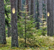
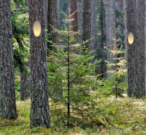
The image to the right shows
a trail in woods waymarked
by cuts in the bark of tree
trunks. This way of marking
the path is called “bläckning”
in Swedish. Image:
Wikipedia.
The milestones marked the beginning of systematic
signposting in Sweden. The milestones themselves
were no signposts, but they were part of a
communication system in which the inns, the stage
driving service, and the road were linked. Signposting
then evolved from this system. Signposting was
formed with Queen Christina's Inn Ordinance of 1649
and is considered to begin with this order.
In the 1734 Law and the newly issued Inn Ordinance, it
was stipulated that "If a road leads to a town, parish,
mill, seaport or other knowable places, then marks must
be set, showing the road to the place. So shall a tablet be
hung at the gate of each inn, listing how far it is to the
next inn, and the fee for a renting a horse to that inn".
However, neither the law nor the inn ordinance
specified what the marks should look like. As a result,
the parishes and districts that set up the signs also
decided what they should look like.
The 1891 Road Act abolished the milestone
system. The Act now provided for signposts: “Where
roads meet, signposts shall be placed; the cost thereof, as
well as for their maintenance, shall be borne by the road
fund”.
During the 1910s, cars became more common and
the need for signposting along the roads became
greater. At the same time, the signposts that existed
at the time were not of a uniform standard and were
perceived as archaic, consisting of milestones and a
number of simple signs at inns. In 1916, the Swedish
Royal Automobile Club (KAK)
developed a type of signs consisting
of a triangle with text underneath
explaining the message of the mark.
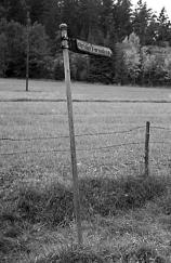
The image to the right shows an old
signpost in Lökeberg, Foss parish,
Bohuslän. Photo: Åke Fredsjö, 1959.
Image: Bohuslän Museum, ID:
UMFA54631:1133..
A few years earlier, at an
international conference in Paris in 1909, a uniform
type of road sign had been decided on, consisting of
round blue panels with white text. Over time, the
European standard became a sort of combination of
the standard set in Paris and the Swedish Royal
Automobile Club (KAK) standard. The KAK triangular
signs evolved into warning signs, while the signs
developed in Paris became prohibition signs. This
standard was spread throughout Europe. In the
beginning, almost all warning and location signs were
yellow with black text and black
characters.
The image to the right shows a
signpost from the 1930s. Image Wikipedia.
From 1958, a new color scheme was introduced
whereby road signs would have a white reflected text
with a background that would be dark blue. From
1978 onwards, the Swedish Road Administration
decided to switch to a new color scale for signs. From
now on, highways would have medium blue signs
while motorways (controlled-access highways) would
have green ones. In countries following the Vienna
convention, the motorway qualification implies that
walking and parking are forbidden.
Road and Travel Maps
A road map is a map mainly adapted for road traffic,
where highways are particularly clearly marked. Many
printed road maps often include outline maps and
several more detailed ones.
Special road and travel maps began to be produced in
Sweden in the 17th century in connection with the
more established organization of the National Land
Survey and increased travel. In 1628, the Office of the
National Land Survey was established and the 1643
land survey ordinance contains specific provisions on
the surveying of roads. Gripenhielm's general map is
Sweden's first general map of "Svea and Göta rike and
the Grand Duchy of Finland", drawn up by the
cartographer Baron Carl Gripenhielm between 1687
and 1688.
In the early 18th century, a series of road maps of the
various parts of the country were produced. However,
ordinary travelers had no access to these maps, as
they were strictly confidential, foremost for military
reasons.
But as travel increased in the 18th century, so did the
need for printed travel maps. In 1730, the National
Land Survey was commissioned to inventory and map
the passable highways in all of Sweden's counties,
indicating inns and post stations. The maps were
drawn by county. The finished result, “Chartebok öfwer
Landswägarna uti Swea och Göta Rike”, was presented
to King Frederick I in 1742. During the 19th century,
many road or travel maps were published and from
the 1860s, steamboat routes and railways were also
usually drawn on the maps.
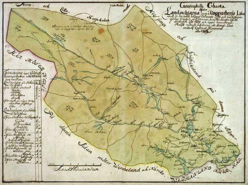
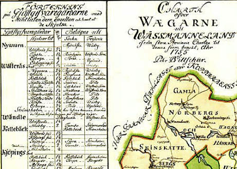
The map below shows the roads in Kopparberg
County, Sweden, in 1742, from “Chartebok öfwer
Landswägarna uti Swea och Göta Rike.” (Road maps of
the highways in Swea and Göta Rike (Sweden)). Image:
National Land Survey of Sweden (Lantmäteriet), Gävle.
i


Related Links
•
Road History, page-1
•
Inns and Stage Services
•
Summer Pasture
•
The Conception of Socken (parish)
•
Domestic Travel Certificates
•
History of the Swedish Police
•
History of Railways in Sweden
•
History of Göta Canal
•
Old Swedish Units of Measurement
•
Agricultural Land Reforms, Sweden
•
Postal Services Formerly
Source References
•
Vägen i kulturlandskapet, vägar och trafik före
bilismen, Vägverket, 2004
•
Det gamla Ytterlännäs, Sten Berglund, 1974.
Utgiven av Ytterlännäs hembygdsförening.
Kapitel 39, sid 368 och framåt.
•
Hur klövjestigen blev landsväg, Gösta Berg, 1935.
(Svenska kulturbilder / Första utgåvan. Andra
bandet (del III & IV), sid 269 och framåt.)
•
Gästgiveri och skjutshåll, Ur det forna reselivets
krönika, av Sven Sjöberg. Ur årsboken Uppland,
1959.
•
Stigen av Lars Levander, 1953
•
Svenska Akademins Ordbok, SAOB (Swedish
Academy Dictionary)
•
Wikipedia
•
Lantmäteriet (The National Land Survey of
Sweden)
Top of page