
Copyright © Hans Högman 2017-06-07


Local History - Rödön Parish and
Hissmofors, Jämtland
Jämtland Province, Sweden
Jämtland province is located in the south-western
parts of the Norrland region.
Jämtland is bounded in the south by Härjedalen
province, in the west by Norway, in the north the
province of Lappland and in the east by the
provinces of Medelpad and Ångermanland.
The province is by large a mountain province with a
lot of ski resorts of which Åre is the best known in
Sweden. The land rises in the west to 1,762 m (5,780
ft) but falls to below 500 m (1,500 ft) in the east.
Jämtland is by area the second largest province in
Sweden. The major city in Jämtland is Östersund. In
central Jämtland there is a large lake, Storsjön.
Jämtland Län (County) constitutes most parts of the
two provinces of Jämtland and Härjedalen.
Rödön Parish and Hissmofors
Rödön parish is located within Krokom municipality.
Hissmofors is located by Indal River (Indalsälven),
close to Krokom town.
Rödön parish was an industrial community in
Jämtland with many industries. In Hissmofors were
for example a hydroelectric power station, saw mill,
paper pulp mill, tobacco company, match plant,
dairy to mentioned a few.
Emma’s occupation as a laborer therefore fits in. In
an industrial community there are many jobs that
wouldn’t fit a woman 100 years ago but I’m sure
many women worked in the match plant or at the
tobacco company and of course at the dairy.
The railroad to Krokom town was opened in 1882.
Industrial enterprises in Hissmofors and
Krokom
•
Hissmofors Sulfite Pulp Plant
(Hissmoforsfabriken). The pulp plant was
established in 1898 and was closed down in
1978.
•
Hissmofors Sawmill (Hissmofors sågverk). The
sawmill opened in 1900 and from the opening
electrically powered.
•
Hissmofors Hydroelectric Power Plant at
Indal River. The construction begun in 1894 and
the power station opened in 1897.
•
Krokom Tobacco Company (Krokoms
tobaksfabrik). The tobacco company
manufactured tobacco products such as
cigarettes and snus. It was located in Dvärslätt,
Krokom. The company was established in 1871
and had about 12 employees. The company
only existed for 21 years; 1871 to 1893.
•
Krokom Match Company (Krokoms
tändsticksfabrik). The raw material for the
matches was aspen wood. About 40 people was
employed by the match company of which 30
were children. The match company was
disestablished in 1908.
•
Dvärsätt Dairy (Dvärsätts mejeri). The dairy
opened in 1889. The dairy had a very large
production of milk. They also produced cream,
butter, hard cheese, whey cheese and other
dairy products.
Historien om hur en svensk
snusdosa hamnade i USA
- Släkten Sjöberg
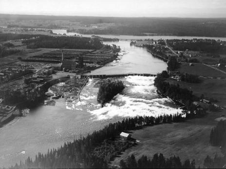
Hissmofors, Krokom, Jämtland in 1929.
The photo shows the Hissmofors Hydroelectric
Power Plant in Indal River (Indalsälven) and to the left
of the river the Hissmofors Sulfite Pulp Plant
(Hissmoforsfabriken).
Free image Wikipedia.
Värmland Province, Sweden
Värmland, province is located in the western part of
the Svealand region.
Värmland is bounded in the north by Dalarna
province, in the south by the provinces of
Västergötland and Dalsland, in the southeast by Lake
Vänern, in the west by Norway and in the east by the
provinces of Västmanland and Närke.
The province of Värmland is in large coextensive with
the county of Värmland.
Major cities: Karlstad, Kristinehamn and Arvika.
Värmland is a well-forested province, especially the
northern part. About 60% of its area is covered by
forest. Evergreens is the dominating type of trees.
Värmland Län (County) constitutes most parts of
Värmland province.
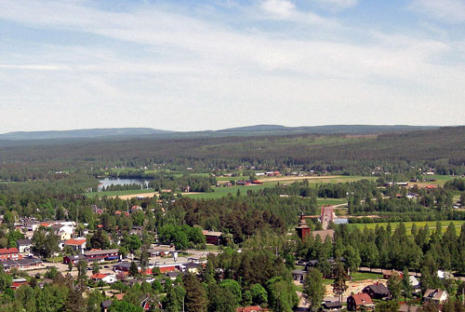
Ekshärad Parish, Värmland
Ekshärad is located in northern Värmland and is
situated within Hagfors municipality by Klarälven
River. The land on both sides of the river is a cultural
landscape but otherwise the parish is a hilly well-
forested district with many lakes. The forests are
dominated by coniferous trees.
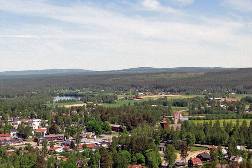
View of Ekshärad, Värmland.
Free image Wikipedia.
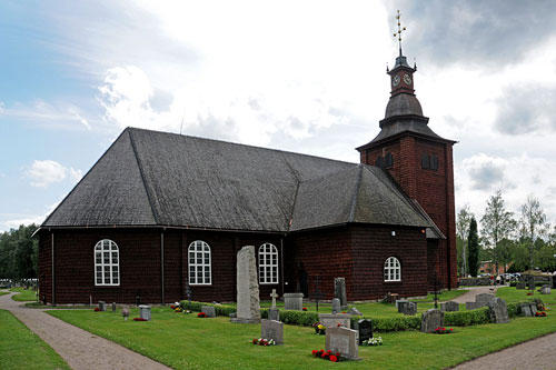
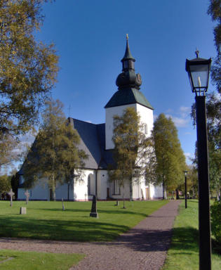
Ekshärad church, Värmland. View from northeast.
There has been a church in Ekshärad since the
Middle Ages. This present church was erected
between 1686-1688.
Free image Wikipedia.

Dalarna Province, Sweden
Dalarna, province is located in the western parts of
central Sweden.
Dalarna is bounded in the west by Norway, in the
north by Härjedalen province, in the south by the
provinces of Västmanland and Värmland and in the
east by the provinces of Hälsingland and Gästrikland.
The area of the province is more or less identical to
the one of the county of Dalarna. The northern and
western parts of the province are mountain areas
with a lot of ski resorts.
Major cities: Falun and Borlänge.
Dalarna Län (County) constitutes most parts of
Dalarna province. Prior to 1997 the county carried
the name Kopparberg Län.
Malung Parish, Dalarna
Malung is located in northern Dalarna, and is situated
within Malung-Sälen municipality by Västerdalälven
River and Lake Öjesjön. The parish is a cultural
landscape in the dale but otherwise a hilly wooded
district with many bogs.
Actually, Malung is not very far from Ekshärad, about
80 km (50 miles).
Malung church, Dalarna.
The church was built in the middle of the 14th
century.
Free image Wikipedia.
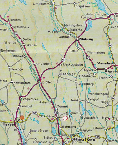
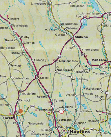
Map covering Ekshärad in Värmland and Malung in
Dalarna.
Ekshärad is located close to the bottom of the map,
by the white spot, while Malung is located at the top
of the map.
As we can see on the map, the two places aren't far
apart; about 80 km (50 miles).
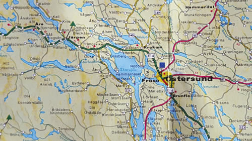
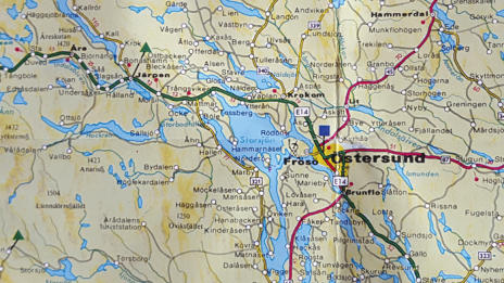
Map covering the central parts of Jämtland
province.
In the middle we see the major city in Jämtland,
Östersund.
Just northwest of Östersund we find Krokom town
where the Sjöberg family lived.
In the far west we also see Järpen where Emma
Sjöberg was born and the ski resort Åre where
Emma's mother Lisa Brita was born.
The great lake is called Storsjön which actually means
"Great Lake". Ås, where Emil Walfrid Sjöberg lived
before his emigration, is located just south of
Krokom.
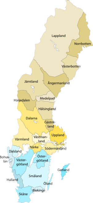
Map of Sweden's provinces.
Jämtland is located in the western part of central
Sweden, bordering Norway to the west.

Related Links
•
The Swedish Emigration to the USA
•
The Johnsons, an emigrant family
•
Military enrollment numbers for conscripts
(draftees)
•
Map of Sweden
Source References
•
Rödön (Z) B:4 (1902-1915) bild 550 / sid 98 (AID:
v115161.b550.s98, NAD: SE/ÖLA/11090)
•
Rödön (Z) B:4 (1902-1915) Bild 690 / sid 126 (AID:
v115161.b690.s126, NAD: SE/ÖLA/11090)
•
Rödön (Z) AIIa:2 (1904-1933) bild 180 / sid 8 (AID:
v228706.b180.s8, NAD: SE/ÖLA/11090)
•
Rödön (Z) AIIa:2 (1904-1933) Bild 550 / sid 45
(AID: v228706.b550.s45, NAD: SE/ÖLA/11090)
•
Rödön (Z) AIIa:2 (1904-1933) bild 670 / sid 57
(AID: v228706.b670.s57, NAD: SE/ÖLA/11090)
•
Undersåker (Z) C:6 (1888-1894) Bild 860 / sid 80
(AID: v115389.b860.s80, NAD: SE/ÖLA/11100)
•
Ås (Z) AIIa:1 (1895-1914) bild 2630 / sid 249 (AID:
v115483.b2630.s249, NAD: SE/ÖLA/11105)
•
Ås (Z) B:2 (1895-1929) bild 520 / sid 46 (AID:
v115487.b520.s46, NAD: SE/ÖLA/11105)
•
Åre (Z) C:5 (1861-1878) bild 370 / sid 33 (AID:
v115465.b370.s33, NAD: SE/ÖLA/11104)
•
Ekshärad (S) AI:29 (1866-1870) Bild 468 / sid 460
(AID: v10786.b468.s460, NAD: SE/VA/13100)
•
Ekshärad (S) AI:30 (1866-1870) Bild 68 / sid 581
(AID: v10787.b68.s581, NAD: SE/VA/13100)
•
Ekshärad (S) AI:32 (1871-1875) Bild 45 / sid 482
(AID: v10789.b45.s482, NAD: SE/VA/13100)
•
Ekshärad (S) AI:32 (1871-1875) Bild 61 / sid 496
(AID: v10789.b61.s496, NAD: SE/VA/13100)
•
Ekshärad (S) AI:34 (1876-1880) Bild 73 / sid 513
(AID: v10791.b73.s513, NAD: SE/VA/13100)
•
Ekshärad (S) AI:36 (1881-1885) Bild 77 / sid 503
(AID: v10793.b77.s503, NAD: SE/VA/13100)
•
Ekshärad (S) AI:38 (1886-1890) bild 75 / sid 65
(AID: v10795.b75.s65, NAD: SE/VA/13100)
•
Ekshärad (S) AI:39 (1891-1895) bild 44 / sid 16
(AID: v10796.b44.s16, NAD: SE/VA/13100)
•
Ekshärad (S) C:6 (1847-1867) Bild 281 (AID:
v6416.b281, NAD: SE/VA/13100)
•
Ekshärad (S) C:9 (1868-1894) bild 283 / sid 627
(AID: v6419.b283.s627, NAD: SE/VA/13100)
•
Malung (W) B:3 (1895-1934) bild 90 / sid 1 (AID:
v184070.b90.s1, NAD: SE/ULA/11213)
•
Malung (W) B:3 (1895-1934) bild 500 / sid 42
(AID: v184070.b500.s42, NAD: SE/ULA/11213)
•
Malung (W) AI:9f2 (1886-1895) bild 94 / sid 90
(AID: v130994.b94.s90, NAD: SE/ULA/11213)
•
Malung (W) AII:1f (1896-1905) bild 260 / sid 14
(AID: v131001.b260.s14, NAD: SE/ULA/11213)
•
Malung (W) AII:2f (1906-1916) bild 200 / sid 10
(AID: v184024.b200.s10, NAD: SE/ULA/11213)
•
Hede (O) C:6 (1870-1894) Bild 82 (AID: v2663.b82,
NAD: SE/GLA/13203)
•
Hede (O) AI:11 (1881-1894) Bild 80 / sid 69 (AID:
v2650.b80.s69, NAD: SE/GLA/13203)
•
Hede (O) AIIa:1 (1895-1916) Bild 790 / sid 75 (AID:
v29382föddb790.s75, NAD: SE/GLA/13203)
•
Hede (O) B:1 (1895-1916) Bild 320 / sid 28 (AID:
v46537a.b320.s28, NAD: SE/GLA/13203)
•
1900 Census, Sweden
•
1910 Census, Sweden
•
The Swedish Death Index 1901 - 2013
•
The Swedish online emigrant database, EmiWeb
The letters within brackets above, after the parish
name, is the county code.
•
O = Göteborgs och Bohus län
•
S = Värmlands län
•
W = Dalarnas län
•
Z = Jämtlands län
Map of Sweden’s provinces