
Copyright © Hans Högman 2021-07-24


Maps, Laga Skifte, Kumla Village,
Toresund Parish (D)
Kumla Village, Toresund Parish
Kumla village is located in Toresund parish, Selebo
härad (hundered), Södermanland County (D). Over
the centuries, the village has consisted of 3 or 4
homesteads (agricultural properties).
Toresund parish is located north of Mariefred town
and east of Strängnäs city and south of the Bay of
Stallarholmen in Lake Mälaren. The parish has
cultivated plains by Lake Mälaren and is otherwise
forested.
In 1933, Toresund parish had 2,406 hectares of
arable land and 3,768 hectares of forest land.
Before the 17th century, the homesteads in Kumla
village were tenant farms under noble landed
estates. In the middle of the 17th century, several of
the homesteads were conferred to Count Mattias
Soop on Mälsåker. The other homesteads were
bought in the 1660s by the commissioner at the
Royal War Office, Anders Nilsson Lillieqvist.
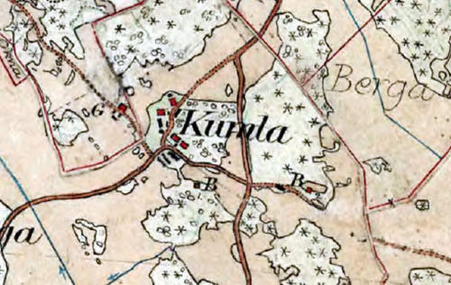
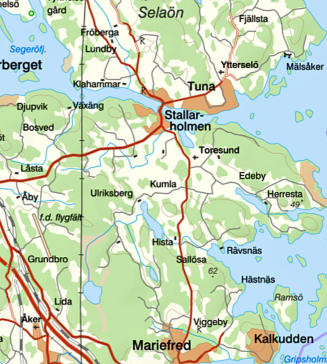
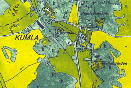
The
map
shows Kumla village and its surroundings. In the
north, you can see Stallarholmen and Selaön
(island), in the south Mariefred. Toresund church is
just north of Kumla. The map also shows the landed
estates of Herresta, Hista, Räfsnäs and Mälsåker.
Map: Lantmäteriet.
The Land Reforms in Kulma
Village
Kumla Village - Storskifte Land Reform
The Storskifte land reform was initiated by the
Riksdag (Parliament) in the 1749 Land Survey
Ordinance, later in a decree from 1757 called the
Grand Land Redistribution (Storskifte).
The land of the village of Kumla was redistributed in
the Storskifte land reform in 1765, 1767, and 1769
under the leadership of the land surveyor Johan
Zetterberg. Kumla village then consisted of the 4
tenant farmsteads; Norrgården, Oppgården,
Nergården and Mellangården. On the land
redistribution map drawn up in 1765 by the surveyor
Zetterberg one can read:
The four homesteads are located in a forest area
about 10 km (6 mi) north of Mariefred town. The
common property of the village: the arable land
consists of hard clay, sandy loam, shallow and stony
moor;" The village pastures were 12 in number.
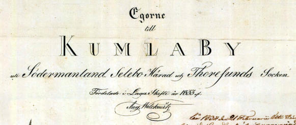
Kumla Village - Laga Skifte Land Reform
In Kumla village, the Laga Skifte land reform was
implemented in 1833/1834 by land surveyor Aug.
Welkevitz.
Oppgården and Nergården farmsteads in Kumla
village were at this time under Mälsåker estate and
Mellangården farmstead was owned by the
Grewesmühl family at Herresta manor. After the laga
skifte, the conditions changed.
Nergården and Oppgården were sold by Major
Count Axel von Fersen on Mälsåker's estate to the
lay judge Eric Zetterberg and the churchwarden
Anders Persson who together now owned these 2
farms.
Norrgården was divided into 4 properties of which
1/6 mantal was owned by the farmer and lay judge
Eric Ersson, 1/12 mantal was owned by Jan Eric
Ersson in Torlunda (son of Eric Zetterberg's stepson
Eric Ersson in Oppgården), 1/8 mantal was owned by
Eric Persson and 1/8 mantal was owned by Eric
Andersson and his maternal grandmother Maria
Jansdotter (died in 1833).
From 1838 Mellangården was under the Hista
estate owned by Conrad Albert Grewesmühl who
had now moved from Räfsnäs Kungsgård - Räfsnäs
demesne of the Crown - (which he leased) to Hista.
According to the Toresund household roll (HFL)
Toresund (D) AI:12 (1833-1837), there are the
following persons on the farms in Kumla village:
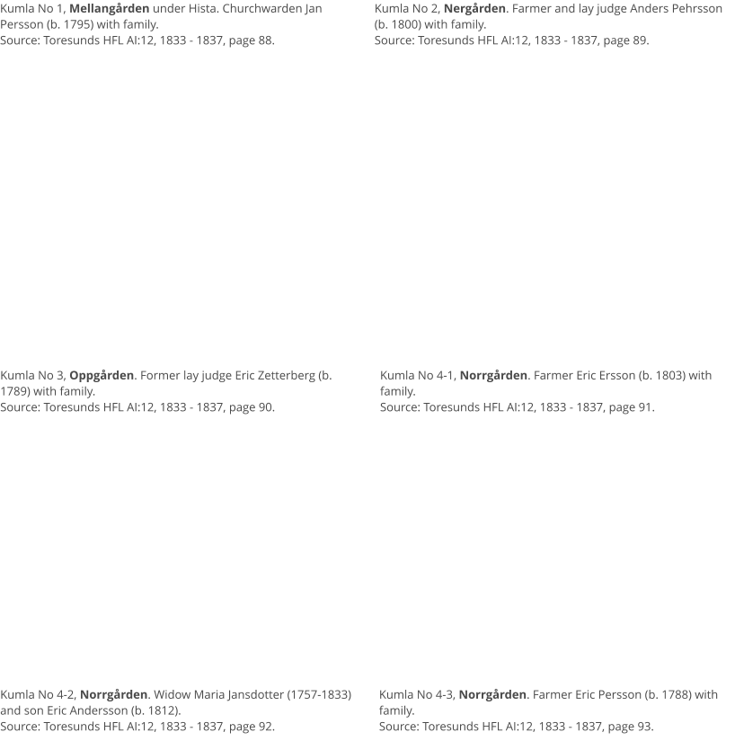
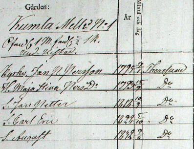
•
Kumla village, Mellangården (No 1) i Toresunds
HFL AI:12, 1833 - 1837, page 88. Churchwarden
Jan Persson
•
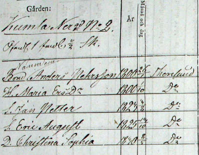
Kumla village, Nergården (No 2) i Toresunds HFL
AI:12, 1833 - 1837, page 89. Farmer and lay judge
Anders Pehrsson.
•
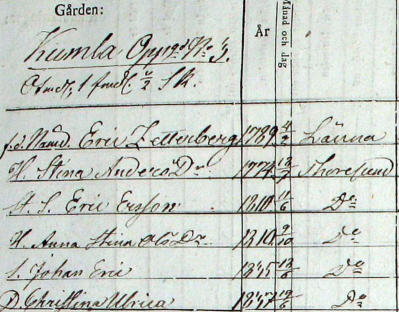
Kumla village, Oppgården (No 3) i Toresunds HFL
AI:12, 1833 - 1837, page 90. Lay judge Eric
Zetterberg.
•
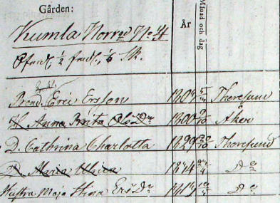
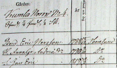
Kumla village, Norrgården (No 4-1) i Toresunds
HFL AI:12, 1833 - 1837, page 91. Farmer Eric
Ersson.
•
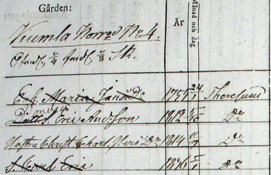
Kumla village, Norrgården (No 4-2) i Toresunds
HFL AI:12, 1833 - 1837, page 92. Widow Maria
Jansdotter / Eric Andersson.
•
Kumla village, Norrgården (No 4-3) i Toresunds
HFL AI:12, 1833 - 1837, page 93. Farmer Eric
Persson.
Extracts from the Household rolls, Kumla
Village, Toresund Parish, 1833 - 1837
Below are excerpts from Toresund's household roll
1833 - 1837 (church records) and shows the families
registered on the respective homestead in Kumla
village at the time of the laga skifte land reform.

Agricultural Land Reforms,
Sweden (3)
A certain exchange of ownership took place between
Kumla village and Torlunda village in 1866 after a
survey carried out by surveyor A. G. Flodin.
About the Land Redistribution
Maps
Land redistribution maps were drawn up in
connection with the land reforms in each village.
Map scales were usually 1:4 000 (100 m, in reality,
corresponds to 25 mm on the map) for the infields
(arable and meadow land) and 1:8 000 for the
outlaying fields (forest land). The acts to the land
redistribution maps may look different, as no fixed
templates were used until after 1850. The
redistribution maps are based on the village as the
principle of division.
The map is accompanied by a description explaining
the numbers and lettering on it. Lower-case letters
are used to mark the old parcels, capital letters
for the new ones. The boundaries are drawn in
black and red.
Note that the maps provide both a snapshot and an
indication of a desired future state. Red lines usually
indicate the boundaries that the redistribution is
intended to establish. Also, some roads and common
areas are intended to be constructed after the
redistribution is completed. Please note that
changes due to appeals may occur!
The land redistribution documents contain
minutes, listing the names and residences of those
present, and annexes, including appeals, and a
description of the redistribution. It shows how the
land was distributed before the division, the grading
of the farmland, and the description of the division of
the various letters (capital letters) of the new parcels.
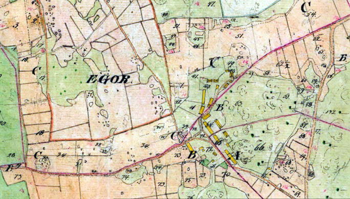
The various colors on the maps represent different
types of land (soil). Fields tend to be yellow, pastures
light green, meadows dark green and, water blue.
There are some variations on this and therefore you
should check with what the description says. There
you can make sure which colors represent which
types of land.
The numbers on the map: the farmlands on the
map are subdivided into smaller parts depending,
among other things, on soil conditions such as
moisture, fertility, etc. Each such area has a number
and that number refers to the charts that appear in
the description of the map

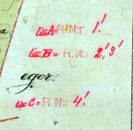
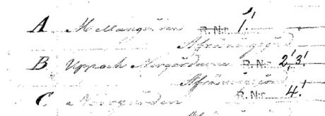
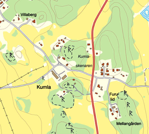
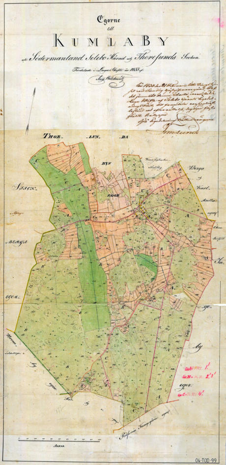
Land Redistribution Map, Laga Skifte, Kumla
Village, 1833
The map below shows the land redistribution map for
the laga skifte land reform at Kumla village in
Toresund parish, drawn up in 1833. The surveyor is
Aug. Welkevitz. Map: Lantmäteriet, Historical maps.


Related Links
•
Agricultural Land Reforms in Sweden
•
Terminology/Dictionary - Land Reforms
•
Agricultural Yields and Years of Famine
•
The Concept of Mantal etc.
•
The Old Agricultural Society and its People
•
Landownership - Farmers & Crofters
•
Crofts and Crofters
•
Summer Pasture
•
The "Statar" system (keeping farm laborers
receiving allowance in kind)
•
The Concept of the Socknen (parish)
•
Property Designations - Sweden
Source References
•
Skiftesreformer i Sverige; Stor-, en- och laga
skifte, Örjan Jonsson JK92/96.
•
De stora förändringarna, 23 Enskiftet och laga
skiftet.
•
Skiftenas skede, laga skiftets handlingar som
källmaterial för byggnadshistoriska studier med
exempel från Småland 1828–1927. Ander
Franzén, 2008.
•
Tegskiftet s. 112-114 i Gadd, Carl-Johan (2000).
Det svenska jordbrukets historia. Kapitel 8, Band
3, Den agrara revolutionen : 1700-1870.
Stockholm: Natur och kultur/LT i samarbete med
Nordiska museet och Stift. Stiftelsen Lagersberg.
•
Bilden av skiftet måste nyanseras, artikel i
tidningen Populär Historia i september 2003 av
Fredrik Bergman, Larserik Tobiasson.
•
Skiftena förändrade Sverige, artikel i tidningen
Släkthistoria i mars 2017 av Therese Safstrom.
•
Lantmäteriet (The National Land Survey of
Sweden)
•
Wikipedia
•
Nationalencyklopedin (Swedish National
Encyclopedia)
•
SAOB (Svenska Akademins Ordbok - The
Swedish Academy Dictionary)
Top of Page